PRE EVENT INFORMATION EMAIL - Find everything you need to know ahead of event day here! (This link will be uploaded on event week)
As the largest area of native forest in Auckland, the Hunua Ranges boast an outstanding selection of glorious single track, stunning bush, fast gravel trails and even a stream crossing or two to keep it interesting! Tucked in the breathtaking heart of this forest you’ll forget you are anywhere near the big city
While the Short and the Mid are an absolute delight for all levels of ability, the longer courses in this location are unashamedly tough! Technical sections and some serious climbing that will give pure joy to those of you that love the challenge!
WE HAVE GONE CUPLESS!
We have removed disposable cups from our aid stations in an effort to minimise our waste production. Please remember your reusable cup, hydration pack or water bottle to fill up! (You can purchase a collapsible silicone water cup at event base for 5$).
IMPORTANT MESSAGE – IT’S UP TO US TO PROTECT OUR KAURI
PLEASE READ THE FOLLOWING INFORMATION TO HELP STOP THE SPREAD OF KAURI DIEBACK
A recent Auckland Council decision on increasing kauri die back protection across the region means a Controlled Area Notice is now in place in parts of the Hunua Ranges. A Controlled Area Notice means there are certain things you must do before visiting these areas.
All footwear, gear and vehicles must be free from all visible soil before entering the park boundary.
Foot wear should then be disinfected once soil has been removed.
Stay on tracks and off Kauri roots.
MPI Control Officers will be in attendance on event day to ensure our compliance.
Please be aware – failure to have clean footwear /gear / vehicles will result in you not being allowed entry to the park. This decision will be made by MPI control officers, not Total Sport staff.
For further information on what you can do to help check out the Keep Kauri Standing website or read the attached files:
Hygiene Procedures (SOP) for those working in Kauri areas (441k pdf)
Kauri PTA Q & A factsheet (214k pdf)
What you can do to help poster (175k pdf)
DRIVING DIRECTIONS
Download driving directions here (378k pdf)
START TIMES
Compulsory event briefings will be held 10 minutes before the start of each event - please be at these!
Super Long Course –9:00 am
Long Course - 9:00am
Mid Course - 10:00am
Short Course - 11:00am
COURSE INFORMATION
We've made it easy for you to gather the whole gang (regardless of age or fitness level), and head out of the city. The Mid and Short courses are available as walks as well as runs, so one event you may get to stretch out in the long or super long while your partner takes a wee whipper snapper or two around the mid or short course.
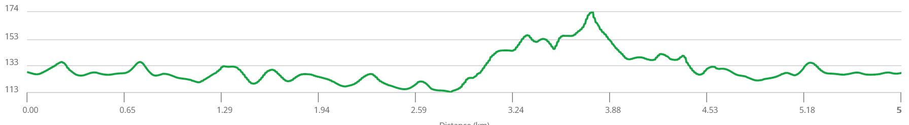
SHORT COURSE
Distance: 6km
Total Climb: 37m
Elevation Profile: Click here to view
Course Overview: Shorties will start in the Upper Mangatawhiri camp site. The course is a 50-50 mix of awesome dirt trail with a couple of little stream crossings and open gravel road. Nothing in there that is too tough on the short course. The gravel is all flat and the trail has a few more ups and downs - watch out for the odd patch of mud and the tree roots that will try and trip you up. Roads and trails used: Blackberry trail, Mangatangi Hill Rd, Moumoukai Valley Rd, River trail.
Drink Stations:
3.5km (with R-Line electrolyte drink, water, chips, pretzels & lollies)
*Please remember your own cup/bottle/hydration pack as there will be no disposable cups provided at drink stations
Toughness Factor: 5/10
GPX File: Click here to download the Short Course GPX file
Participant Briefing: Click here to view
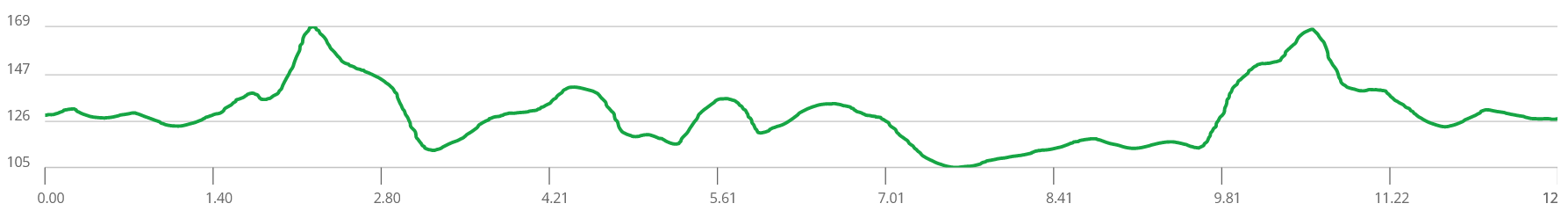
MID COURSE
Distance: 12km
Total Climb: 71m
Elevation Profile: Click here to view
Course Overview: Start in the Upper Mangatawhiri camp site. The course is a 50-50 mix of groomed off road trails and sleepy gravel roads - with a couple of little stream crossings in the mix. There is some undulating stuff when you get into the single track which will keep you honest. Road/ trails used: Blackberry trail, Mangatangi Hill Rd, Moumoukai Valley Rd, River trail, Farm trail, Manning Rd.
Drink Stations:
3.5km (with R-Line electrolyte drink, water, chips, pretzels & lollies)
8.5km (with R-Line electrolyte drink, water, chips, pretzels & lollies)
*Please remember your own cup/bottle/hydration pack as there will be no disposable cups provided at drink stations
Toughness Factor: 6/10
GPX File: Click here to download the Mid Course GPX file
Participant Briefing: Click here to view
LONG COURSE (Run Only)
Distance: 17.5km
Total Climb: 640m
Elevation Profile: Click here to view
Course Overview: Start in the Upper Mangatawhiri campsite. This (along with the Super Long Course) has a number of steep climbs and some technical running through narrow tramping tracks that have a bit of mud and lots of tree roots to catch you out. It is important to stay alert and maybe sacrifice some speed for accuracy of foot placement. Be prepared for a good workout!
Road/trails used: Blackberry trail, Mangatangi Hill Rd, Moumoukai Valley Rd, River trail, Farm trail, Manning Rd, Graeme White Rd, ARA Drive, Pukapuka Track, Lilburne Rd across the Dam face.
PLEASE READ THE COURSE SAFETY SECTION IN REGARDS TO COMPULSORY EQUIPMENT AND CUT OFF TIMES.
Drink Stations:
3.5km (with R-Line electrolyte drink, water, chips, pretzels & lollies)
5.3km (with R-Line electrolyte drink, water, chips, pretzels & lollies)
8km (with R-Line electrolyte drink, water, chips, pretzels, lollies & oranges)
14km (with R-Line electrolyte drink, water, chips, pretzels , lollies & oranges)
*Please remember your own cup/bottle/hydration pack as there will be no disposable cups provided at drink stations
Toughness Factor: 9/10
GPX File: Click here to download the Long Course GPX file
Participant Briefing: Click here to view
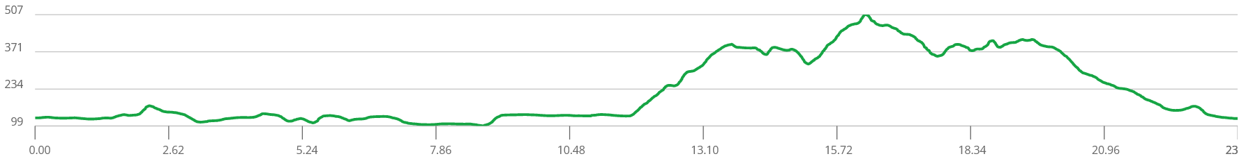
SUPER LONG COURSE (Run Only)
Distance: 21km
Total Climb: 662m
Elevation Profile: Click here to view
Course Overview: Start in the Upper Mangatawhiri campsite. This (along with the Long Course) has a number of steep climbs and some technical running through narrow tramping tracks that have a bit of mud and lots of tree roots to catch you out. It is important to stay alert and maybe sacrifice some speed for accuracy of foot placement. Be prepared for a good workout!
Road/trails used: Blackberry trail, Mangatangi Hill Rd, Moumoukai Valley Rd, River trail, Farm trail, Manning Rd, Graeme White Rd, ARA Drive, Pukapuka Track, Lilburne Rd across the Dam face.
PLEASE READ THE COURSE SAFETY SECTION IN REGARDS TO COMPULSORY EQUIPMENT AND CUT OFF TIMES.
Drink Stations:
3.5km (with R-Line electrolyte drink, water, chips, pretzels & lollies)
8.5km (with R-Line electrolyte drink, water, chips, pretzels & lollies)
11.5km (with R-Line electrolyte drink, water, chips, pretzels, lollies & oranges)
17.5km (with R-Line electrolyte drink, water, chips, pretzels, lollies & oranges)
*Please remember your own cup/bottle/hydration pack as there will be no disposable cups provided at drink stations
Toughness Factor: 9/10
GPX File: Click here to download the Super Long Course GPX file
Participant Briefing: Click here to view
COURSE SAFETY
LONG AND SUPER LONG COURSE
Due to the exposed nature of the Hunua Super Long and Long course’s, participants will be required to carry mandatory equipment. Specifically:
Long sleeve top (polyprop or wool)
Beanie (polyprop or wool)
Survival blanket
Waterproof seam sealed jacket
Gloves (polyprop or wool)
We will conduct spot checks on the start line and will strictly enforce the mandatory equipment rule. Non-compliance will result in disqualification or participants will be transferred to the mid/short, there will be no exceptions. This is for safety reasons due to the isolated and exposed nature of the super course.
Course Cut Off: For safety reasons there will be a cut off for the Long and Super Long at the entrance of the Pukapuka Track.
Long Course - 11.00am cut off (9.7km from start)
Super Long - 11.30am cut off (13.6km from start)
Bad Weather Contingency: In the event of poor weather, event staff may choose to adjust the Super Long and Long course’s for safety. Should this occur, a map of the contingency course will be posted on the 'Event Information' board, outside registration and participants will be notified by event staff.
GENERAL
We recommend running with a Hydration back pack loaded with 500ml - 1 litre of liquid, and other nutritional nibbles. You can expect to be away from base for a decent period of time at these events, and we can't always get aid stations to the points where you may expect them to be.
While event medics will be at each event (they will be stationed at the event base, start / finish point) and participants may encounter on course marshals with first aid on them, it also pays to be safety conscious and carry items like:
a basic first aid kit
a cell phone
a whistle
additional warm clothing
Should you come across an injured participant, stop and apply first aid if you are trained. Send the next participant through to the next marshal or course crew location (or back if you had recently past one) and notify them of the participants; race number, name, location and description of incident.
If you happen to become lost or disoriented on course, stop and remain calm before retracing your steps to the last know course marking. If you still cannot find the course marking, stop and put on your additional warm clothing and blow your whistle.
It's all about personal responsibility!
Participant Briefing: Click here to view