PRE EVENT INFORMATION EMAIL - Find everything you need to know ahead of event day here! (This link will be uploaded on event week)
Tucked away on the south east coast of Auckland this hidden gem makes for some truly stunning running conditions!
Made up of three small peninsulas Waitawa boasts outstanding views across the Firth of Thames on every peak and some wicked sections of native bush packed with neat trails just screaming out to be used.
This one is a also a good entry level course with enough undulation to certainly keep it interesting but without the intimidating elevation or very technical terrain of some of the other locations. And did we mention the views?!
DRIVING DIRECTIONS & TRANSPORT INFORMATION
Event base location is 1191 Clevedon-Kawakawa Road, Kawakawa Bay, 2585.
Parking is always a challenge at this one as we are at the mercy of the weather for chance of dry(ish) parking paddocks for parking. It won’t come as much of a surprise that NOTHING is dry this year 🙄
Without any dry paddocks parking is going to be TIGHT, so we’d really appreciate any help at all in reducing the number of cars coming to the event. If you could share a ride you’d be helping out both us and the environment!
if you’d like to find yourself some new car buddies, head over to the Auckland XTERRA Series Carpooling Group.
WE HAVE GONE CUPLESS!
We have removed disposable cups from our aid stations in an effort to minimise our waste production. Please remember your reusable cup, hydration pack or water bottle to fill up! (You can purchase a collapsible silicone water cup at event base for 5$).
IMPORTANT MESSAGE – IT’S UP TO US TO PROTECT OUR KAURI
PLEASE READ THE FOLLOWING INFORMATION TO HELP STOP THE SPREAD OF KAURI DIEBACK
What you can do to help poster (175k pdf)
Hygiene Procedures (SOP) for those working in Kauri areas (441k pdf)
Kauri PTA Q & A factsheet (214k pdf)
START TIMES
Compulsory event briefings will be held 10 minutes before the start of each event - please be at these!
Super long – 9:00am
Long – 9:00am
Mid – 10:00am
Short – 11:00am

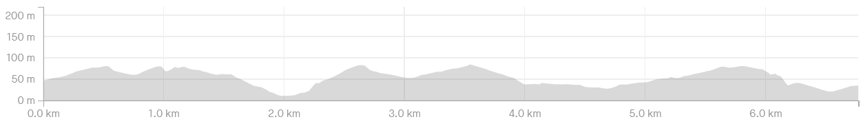
SHORT COURSE
Distance: 6.5km
Total Climb: 130m
Elevation Profile: Click here to view
Course Overview: There’s a nice 400m stretch of open paddock to begin with, which will allow you to jostle for position before hitting the sweet single track. Many of these trails have been sculpted with mountain bikes in mind. That means bermed corners (which are wicked fun) and fast rolling sections, guaranteed to suit the speedsters. The first few kms are undulating single track through open farmland. There is a gradual climb to a high point, and some stunning views once you get there.
There are a couple of uphill climbs to conquer from here, before you finish, so make sure you save some energy for this (and I’ll apologise now)!
Drink Stations:
3.2km & 6.4km (with water, R-Line electrolyte drink, potato chips, pretzels & lollies)
*Please remember your own cup/bottle/hydration pack as there will be no disposable cups provided at drink stations
Toughness Factor: 5/10
GPX File: Click here to download the Short Course GPX file
Participant Briefing: Click here to view
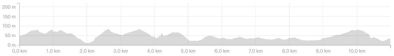
MID COURSE
Distance: 11.7km
Total Climb: 329m
Elevation Profile: Click here to view
Course Overview: There’s a nice 400m stretch of open paddock to begin with, which will allow you to jostle for position before hitting the sweet single track. Many of these trails have been sculpted with mountain bikes in mind. That means bermed corners (which are wicked fun) and fast rolling sections, guaranteed to suit the speedsters. The first few kms are undulating single track through open farmland, followed by a stunning trail that descends through the bush – with sea views in the mix. A steady climb back up to a carpark and you’re rewarded with close to 360 degree views at the top. Here you can see Pakihi Is, Ponui Is & Waiheke Island. You’ll also see where you’re heading next – down, all the way down to the ocean. Enjoy that fast downhill cause she’s a steep, slow climb back to the top but well worth the effort as you drop down the other side with picturesque views across to Kawakawa Bay - which is right next door by the way.
There are a couple of uphill climbs to conquer from here, before you finish, so make sure you save some energy for this (and I’ll apologise now)!
Drink Stations:
4km, 7.8km & 10.5km (with water, R-Line electrolyte drink, potato chips, pretzels & lollies)
*Please remember your own cup/bottle/hydration pack as there will be no disposable cups provided at drink stations
Toughness Factor: 5/10
GPX File: Click here to download the Mid Course GPX file
Participant Briefing: Click here to view
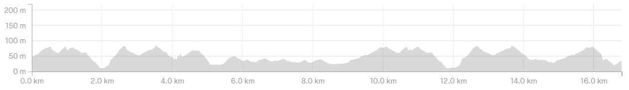
LONG COURSE (Run Only)
Distance: 17.3km
Total Climb: 488m
Elevation Profile: Click here to view
Course Overview: There’s a nice 400m stretch of open paddock to begin with, which will allow you to jostle for position before hitting the sweet single track. Many of these trails have been sculpted with mountain bikes in mind. That means bermed corners (which are wicked fun) and fast rolling sections, guaranteed to suit the speedsters. The first few kms are undulating single track through open farmland, followed by a stunning trail that descends through the bush – with sea views in the mix. A steady climb back up to a carpark and you’re rewarded with close to 360 degree views at the top. Here you can see Pakihi Is, Ponui Is & Waiheke Island. You’ll also see where you’re heading next – down, all the way down to the ocean. Enjoy that fast downhill cause she’s a steep, slow climb back to the top but well worth the effort as you drop down the other side with picturesque views across to Kawakawa Bay - which is right next door by the way. Another couple kms of up and down before you pass the finish shoot on your right, and head back out. Only this time, you’ll likely be travelling a little slower which will enable you to really absorb the views on as you go – perfect! You’ll split from the other courses at the main gate this time, essentially cutting the course in half, and taking a shortcut to the finish.
There are a couple of uphill climbs to conquer (on the first and second lap), before you finish, so make sure you save some energy for this (and I’ll apologise now)!
Drink Stations:
4km, 7.8km, 10.6km, 14.3km & 16.3km (with water, R-Line electrolyte drink, potato chips, pretzels & lollies)
*Please remember your own cup/bottle/hydration pack as there will be no disposable cups provided at drink stations
Toughness Factor: 6/10
GPX File: Click here to download the Long Course GPX file
Participant Briefing: Click here to view
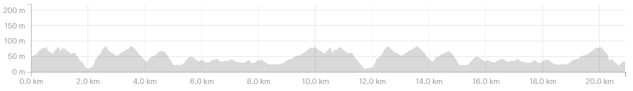
SUPER LONG COURSE (Run Only)
Distance: 21.5km
Total Climb: 501m
Elevation Profile: Click here to view
Course Overview: There’s a nice 400m stretch of open paddock to begin with, which will allow you to jostle for position before hitting the sweet single track. Many of these trails have been sculpted with mountain bikes in mind. That means bermed corners (which are wicked fun) and fast rolling sections, guaranteed to suit the speedsters. The first few kms are undulating single track through open farmland, followed by a stunning trail that descends through the bush – with sea views in the mix. A steady climb back up to a carpark and you’re rewarded with close to 360 degree views at the top. Here you can see Pakihi Is, Ponui Is & Waiheke Island. You’ll also see where you’re heading next – down, all the way down to the ocean. Enjoy that fast downhill cause she’s a steep, slow climb back to the top but well worth the effort as you drop down the other side with picturesque views across to Kawakawa Bay - which is right next door by the way. Another couple kms of up and down before you pass the finish shoot on your right, and head back out and complete a second lap of the park, only this time, you’ll likely be traveling a little slower which will enable you to really absorb the views on as you go – perfect!
There are a couple of uphill climbs to conquer (on the first and second lap), before you finish, so make sure you save some energy for this (and I’ll apologise now)!
Drink Stations:
4km, 7.8km, 10.5km, 14.2km, 17.9km & 20.5km (with water, R-Line electrolyte drink, potato chips, pretzels & lollies)
*Please remember your own cup/bottle/hydration pack as there will be no disposable cups provided at drink stations
Toughness Factor: 6/10
GPX File: Click here to download the Super Long Course GPX file
Participant Briefing: Click here to view
COURSE SAFETY
We recommend running with a Hydration back pack loaded with 500ml - 1 litre of liquid, and other nutritional nibbles. You can expect to be away from base for a decent period of time at these events, and we can't always get aid stations to the points where you may expect them to be.
While event medics will be at each event (they will be stationed at the event base, start / finish point) and participants may encounter on course marshals with first aid on them, it also pays to be safety conscious and carry items like:
a basic first aid kit
a cell phone
a whistle
additional warm clothing
Should you come across an injured participant, stop and apply first aid if you are trained. Send the next participant through to the next marshal or course crew location (or back if you had recently past one) and notify them of the participants; race number, name, location and description of incident.
If you happen to become lost or disoriented on course, stop and remain calm before retracing your steps to the last know course marking. If you still cannot find the course marking, stop and put on your additional warm clothing and blow your whistle.
It's all about personal responsibility!
Participant Briefing: Click here to view